 Institute for Research and Applications of Fuzzy Modeling
University of Ostrava, Czech Republic
Contact
30. dubna 22701 03 Ostrava 1
Czech Republic
Fax: +420 596 120 478
Paths in the Landscape
Multisensor input images.
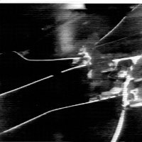
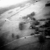
We start with the well known benchmark, which is described and can be downloaded from the following site "http://www.metapix.de". It contains two input images taken by two sensors: a thermal imaging forward-looking infrared (FLIR) sensor and a low-light television (LLTV) sensor. The sensors were used together in a helmet-mounted display intended for a helicopter pilot. The goal here was to extract and fuse the most important characteristics of the scene, i.e., the paths and their localization in the landscape.
 |
 |
first input image - FLIR |
second input image - LLTV |
SA was deemed the most suitable for this application due to its low computational complexity. The results of the SA fusion were compared with the benchmark fusion (available on the same web site) based on a multiresolution analysis. The quality of our result is visibly better. We note that the CA produced a fusion of even better quality, although at the cost of higher computational complexity.
SA with n,m=100 |
CA with |
© 2007 Institute for Research and Applications of Fuzzy Modeling, University of Ostrava, Czech Republic
